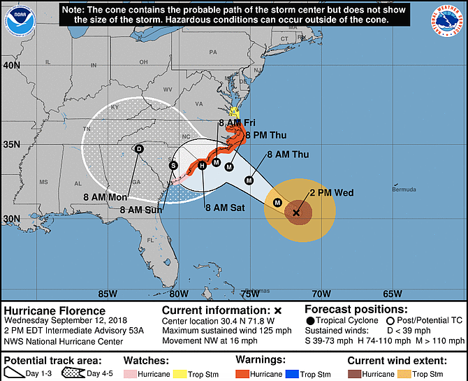
Closing in with terrifying winds of 125 mph (205 kph) and potentially catastrophic rain and storm surge, Florence is expected to blow ashore Saturday morning along the North Carolina-South Carolina line, the National Hurricane Center said.
WILMINGTON, N.C. (AP) — People who thought they were relatively safe from the onslaught of Hurricane Florence began boarding up and Georgia's governor declared a state of emergency Wednesday as uncertainty over the path of the monster storm spread worry along the Southeastern coast.
Closing in with terrifying winds of 125 mph (205 kph) and potentially catastrophic rain and storm surge, Florence is expected to blow ashore Saturday morning along the North Carolina-South Carolina line, the National Hurricane Center said.
While some of the computer forecasting models conflicted, the latest projections more or less showed the storm shifting southward and westward in a way that suddenly put more of South Carolina in danger and imperiled Georgia, too.
At the White House, President Donald Trump urged people to "get out of its way."
"Don't play games with it. It's a big one," he said.
With the change in the forecast, Georgia Gov. Nathan Deal issued an emergency declaration for the entire state to ease regulations on trucks hauling gasoline and relief supplies, and asked people to pray for those in Florence's path. North and South Carolina and Virginia declared emergencies earlier in the week.
The shift in the projected track had areas that once thought they were out of range worried. In South Carolina, Beaufort County Emergency Management Division Commander Neil Baxley told residents they need to prepare again for the worst just in case.
"We've had our lessons. Now it might be time for the exam," Baxley said late in the morning.
As of 2 p.m., the Category 3 storm was centered 435 miles (700 kilometers) southeast of Wilmington, moving at 16 mph (26 kph), with the potential for 1 to 3 feet of rain in places — enough to touch off catastrophic flooding inland and an environmental disaster, too, if the water inundates the region's many industrial waste sites and hog manure ponds.
The hurricane center's projected track had Florence hovering off the southern North Carolina coast starting Thursday night before finally blowing ashore. That could punish a longer stretch of coastline, and for a longer period of time, than previously thought.
The trend is "exceptionally bad news," said University of Miami hurricane researcher Brian McNoldy, since it "smears a landfall out over hundreds of miles of coastline, most notably the storm surge."
If some of the computer projections hold, "it's going to come roaring up to the coast Thursday night and say, 'I'm not sure I really want to do this, and I'll just take a tour of the coast and decide where I want to go inland,'" said Jeff Masters, meteorology director of the private Weather Underground forecasting service.
As of Tuesday, about 1.7 million people in North and South Carolina and Virginia were under warnings to evacuate the coast, and hurricane watches and warnings extended across an area with about 5.4 million residents. Cars and trucks full of people and belongings streamed inland.
"This is not going to be a glancing blow," warned Jeff Byard, an administrator with the Federal Emergency Management Agency. "This is going to be a Mike Tyson punch to the Carolina coast."
Florence could strengthen some over open water and then weaken as it nears land, but the difference won't make it any less dangerous, forecaster Stacy Stewart wrote in a National Hurricane Center discussion.
With South Carolina's beach towns more in the bull's-eye because of the shifting forecast, Ohio vacationers Chris and Nicole Roland put off their departure from North Myrtle Beach to get the maximum amount of time on the sand. Most other beachgoers were long done.
"It's been really nice," Nicole Roland said. "Also, a little creepy. You feel like you should have already left."
For many of those under evacuation orders, getting out of harm's way has proved difficult, as airlines canceled flights and motorists had a hard time finding gas.
Michelle Stober loaded up valuables at her home on Wrightsville Beach to drive back to her primary residence in Cary, North Carolina.
"This morning I drove around for an hour looking for gas in Cary. Everyone was sold out," she said.
Copyright Associated Press. All rights reserved. This material may not be published, broadcast, rewritten, or redistributed.


Comments
Use the comment form below to begin a discussion about this content.
comments powered by Disqus